Should we build a bridge across Knik Arm?
Click on the links at left to jump to sections of this page.
Where is Knik Arm?
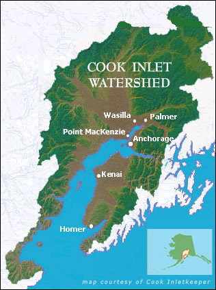
Knik Arm is a branch of Cook Inlet, a 192 mile long estuary that stretches from the Gulf of Alaska between the Kenai Peninsula and mainland southcentral and southwestern Alaska. Knik Arm begins at the Inlet's northern edge, starting near Anchorage and heading north and east (see Map modified from the Cook Inlet Keeper website).
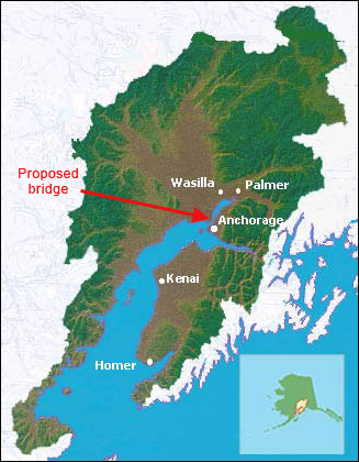
The proposed Knik Arm bridge would stretch approximately 2 miles from Point MacKenzie on the west (in the Mat-Su Borough) to Anchorage on the east.The crossing would be less then five miles north of Anchorage.
Will the bridge reduce commute times or relieve congestion?
No.
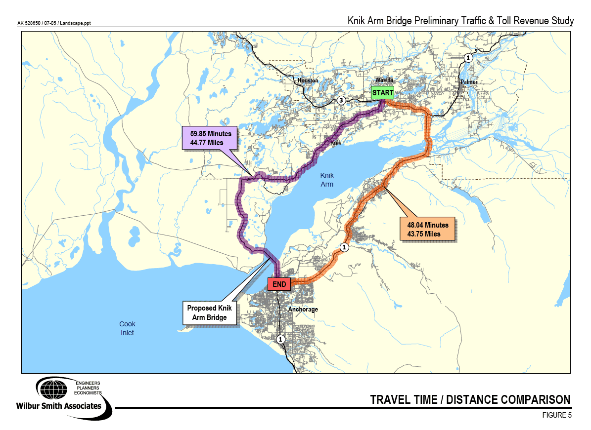
The vast majority of people traveling to Anchorage to work from the Mat-Su Borough will continue to drive the Glenn Highway because it will continue to be the faster, toll-free route into Anchorage. Only residents living in rural areas like Big Lake, Houston, and Point MacKenzie will find the bridge route more efficient (see the time and distance analysis done by Wilbur Smith Associates) Additionally, the bridge will add to Anchorage's downtown congestion.
How much will the bridge cost?
Two recent studies provided the following estimates of bridge costs:
Estimated Costs for the Knik Arm Bridge and Its Access Roads
| Study Author | Phase 1 | Phase 2 | Total Cost |
| The National Constructors Group (1/09) | $686 million | Not analyzed | Not analyzed |
| Federal Highway Administration (90% likelihood, 5/09) | $670-$740 million | $750-$920 million | $1.5-$1.6 billion |
Phase 1 represents a 2-lane bridge with a connection to A and C Streets downtown Anchorage and Phase 2 represents expansion to a 4-lane bridge with a connection to Ingra-Gambell Streets (i.e., the Seward Highway) outside of downtown. The National Constructors Group [Dead link-this study is no longer online.] independent engineering study argues that state or local financial participation is critical for the project to move forward. The Federal Highway Administration study assumed an 8,200' bridge with filled-in causeways on both sides. Several key federal resource protection agencies, however, prefer a 14,000' bridge to retain Knik Arm's tidal flows. Such a bridge would cost significantly more, and may be required by these agencies in order to protect the endangered Cook Inlet beluga whale.
How do communities know they need a bridge?
Historically, bridges were constructed when ferry service was unable to handle the number of people needing to cross a waterway.
Who will benefit from the bridge? Who will lose out?
Those who may benefit from the bridge include:
- Residential and industrial/commercial developers in the Point MacKenzie area
- Landowners in the Point MacKenzie area
- New homeowners in Point MacKenzie (but many of these homeowners will pay a daily toll to travel to work, reducing the financial gain from cheaper housing)
- Bridge-related construction firms
Those who may lose out from the bridge include:
- Downtown Anchorage businesses and cultural institutions
- Anchorage bowl residential property and business owners, whose homes and businesses will not increase in value as much as they would without a bridge
- Mat-Su Borough property owners whose taxes likely will increase to fund access roads and/or new infrastructure needed because of the bridge
- Communities throughout the state that will lose state transportation funds to pay for the Knik Arm bridge instead
- Government Hill residents, who will have a highway through their close-knit, historic neighborhood
Who will pay for the bridge? Won't tolls fund the bridge?
The Federal Highway Administration in 2009 released a study that showed there's a 90% probability the two phases of the bridge will cost approximately $1.5 billion (Phase 1 is a two-lane bridge and an access road through downtown Anchorage, Phase 2 is a four-lane bridge and an access road connecting to the Seward Highway).
In the summer of 2005, the U.S. Congress granted a $231 million earmark for the bridge. After overwhelming national criticism over spending massive amounts of federal tax dollars on "bridges to nowhere," Congress removed its mandate to spend the $231 million on the Knik Arm bridge project. The State of Alaska allocated $93.6 million for the bridge in federal money and small amounts of state money.
The Knik Arm Bridge and Toll Authority (KABATA) currently is negotiating with private investors as part of a public-private partnership. Given the worldwide credit downturn, however, it is unlikely this project is fundable via that means since toll revenues will not be sufficient for this project to be worth the investment. KABATA does not have a financial plan that addresses current problems with private funding.
How much has been spent on the bridge to date?
KABATA has spent over $91 million to date in planning to construct the bridge. In the state's fiscal year ending June 2009, KABATA spent over $13,400 per day. As a comparison, Anchorage spends approximately $22 million each year to meet all its road, public transportation, sidewalk, and trail needs.
What are the perceived needs for the bridge?
The Knik Arm bridge was proposed to meet a variety of needs both for Anchorage and the nearby
Mat-Su Borough. These perceived needs include:
- a. Accessing cheap land for homes as the region's population grows.
- b. Improving the Anchorage region's economy with increased developable lands.
- c. Facilitating cargo movement between Anchorage and points north.
- d. Reducing commuter travel time between Anchorage and the Mat-Su Borough.
- e. Increasing safety through multiple entrance and exit points to Anchorage.
Can the needs be met in other ways?
Yes
- a. Residential housing can be built in the Anchorage bowl in higher density housing/mixed-use developments, and affordable homes can be built throughout the Mat-Su Borough, not only near Point MacKenzie. Building near existing school, police, sewer infrastructure reduces property taxes.
- b. The region's economic growth can and should occur throughout the Mat-Su Borough, not just near Point MacKenzie. Additionally, the Municipality of Anchorage has many areas of unused land, including land north of Anchorage in Eagle River, Chugiak, etc. There is not an industrial land shortage for future decades according to a recent (2009) analysis [Dead link-this analysis is no longer online.] .
- c. Cargo can be moved north from Anchorage via ferry, via the Alaska Railroad, and via the existing Glenn and Parks Highways. It may be wise to consider a Wasilla bypass road to ensure safe, efficient passage of cargo through the Wasilla area.
- d. Commuter travel time can be reduced in many ways including decreased highway accidents and prompt accident removal, travel via commuter rail and commuter ferries, easing parking restrictions for carpoolers and vanpoolers, more telecommuting, etc. Additionally, business development in the Mat-Su Borough itself, including satellite offices for large Anchorage employers, will result in fewer commuters to Anchorage.
- e. Upgraded rail service and ferry service can facilitate entering and exiting Anchorage.
What are the alternatives to the proposed bridge?
During the public comment period for the National Environmental Policy Act (NEPA) "scoping" period, the public proposed two primary alternatives to the bridge:
1. Four road route alternatives through Elmendorf Air Force Base connecting to downtown Anchorage via Post Road/Reeve Boulevard, Boniface Parkway, Muldoon Road, or Hiland Road, respectively (see map); and
2, A four-part, non-bridge alternative (see map) consisting of:
- 1) Vehicle/cargo ferry service between Point MacKenzie and Anchorage
- 2) Commuter/cargo rail between the Mat-Su Borough and Anchorage
- 3) Carpool and vanpool incentives for travel along the Glenn Highway between the Borough and Anchorage
- 4) Expanded bus service and potential streetcar transit in Anchorage (to ensure easy movement within Anchorage)
Although it is supposed to analyze all reasonable alternatives in the NEPA Environmental Impact Statement, in its Scoping Summary Report issued in November 2005, the Federal Highway Administration (FHWA) rejected all the road route alternatives through Elmendorf as "not reasonable" because they are slightly more inconvenient for most travelers to Anchorage and cost more than the more-direct road route through Government Hill. This decision ignored the primary benefit of the road route alternatives through Elmendorf - preserving the neighborhood integrity of Government Hill.
Similarly, the FHWA also considered the four-part, non-bridge alternative "not reasonable" even though it was designed to meet the same need criteria as the bridge, and would do so at a small fraction of the cost of the bridge and its access roads.
What will the bridge's toll be?
Wilbur Smith Associates, an infrastructure consulting firm and a consultant to KABATA, estimated that the toll would be $5 each way for passenger vehicles (2007).
Isn't the bridge "dead"?
The Anchorage Assembly voted in 2008 to begin a process to remove the bridge from the community's Long Range Transportation Plan. Anchorage's transportation decision-maker, AMATS (which stands for Anchorage Metropolitan Area Transportation Solutions), has looked into doing so and, as of early 2010, is considering moving bridge construction to 2018 or later. Such a move does not stop spending on the bridge, but could decrease the amount spent annually.
